The Basics 2
Introduction
In the "Basics 2" lesson, we will focus on these objectives:
- Add features to a map
- Remove features from a map
- Understand 'reference cartography'
- How to make layers (grids, ZIPs) show up or disappear.
- Adjust line style, fill, and object symbols
- Understand zoom ranges
- Adjust color ranges in thematic maps
- Control Label size and placement
- Show and hide Legends
- Basic legend editing
- Load ZIPs and MicroGrids by choosing themes
Of course, the basic "operational rules" we talked about in 'Basics 1' still apply, especially:
Scan/US Rule 1: Be able to identify the active map layer.
Quick review of new study area and the collections of map layers and their appearance that we refer to as themes
This section is about things you can do on the top section of the Scan US tools menu
Let's get started by removing features from a map.
Remove features from a map
Since map themes exist to load a collection of features together at once, you may wish to start with a map theme, and then remove a feature.
We will start by showing how to remove the counties from a map that shows only states and counties -- apparently. If you completely understand this simple example, it will remove a lot of frustration in dealing with customizing maps!
Plus, you will learn about layers classed as reference cartography, and how to control how they are displayed in the map layers dialog.
The following diagram shows the the Map Layers dialog (choose Map Layers.. from the map menu) on top of a map with states and counties.
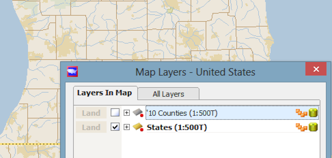
The map layers dialog
Notice the two tabs, above: "Layers in Map", and "All Layers". The first of these shows the layers which ARE in the map, while the second, 'all layers', shows the layers which you COULD put into the map. Since we are removing a layer, we will have no further discussion of the "All Layers" tab at this moment.
The list of layers is short: counties and states. The checkbox next to States indicates that it appears in the map, while the empty checkbox next to '10 Counties' indicates that the counties layer has been hidden.
However, as you look at the map, you may notice county borders forming a pattern of county-shaped objects all across Michigan.
"These look like counties!" you may say. "I don't want to see counties. How can I make them go away?"
The answer to this question has two parts. The first part is that every standard Census cartography layer is present in two guises: data-containing polygons with borders around them (known as 'polygons'), and line-only boundaries which contain no data and are just drawn around those polygons (known as 'boundaries').
What has happened in the example above, is that the '10 Counties' layer has been "un-checked" and made to be hidden. But the OTHER county layer, the '10 County Boundaries', is still in the map.
The second part of the answer to 'how to make the counties disappear', is that in order to make the Map Layers list appear shorter, some of the non-data-bearing layers have been classified as "Reference Cartography". "Reference Cartography" consists of map layers that are there just for decoration. In your normal data-analysis operation, you only want to look at data-bearing layers. Therefore, there is a checkbox at the bottom of the Map Layers dialog (shown by green arrow below), that you can use to look at the list. When you click this, a whole bunch of new layers appear. UN-check the box next to '10 County Boundaries', and the county boundaries will disappear.
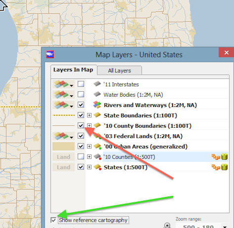
The map layers dialog
You can bring them back at any time by checking the checkbox. If you want to take them out of the map entirely, right-click on the name of the layer, and a context menu will appear:
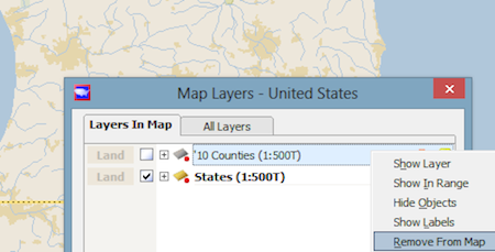
context menu showing remove from map
How can I see layers like grids or ZIPs?
Create a new study area with appropriate theme
-- or --
Go to the all layers tab, and find your layer
The easiest way to add ZIP codes to a map is to create a new study area, and choose a theme with ZIPs already in it. The same is true with MicroGrids: the Standard Local (35) Standard Metro (100), and Large Metro (150) themes all have MicroGrids as part of the theme.
After you create the study area, open Map Layers from the Map Menu, and click the checkbox next to MicroGrids (shown by green arrow below):

Check the box to see grids on the map
When you do this, MicroGrids will appear on the map as the current layer.
Another way
If you have already created an appropriately-sized study area, you may go to the "All Layers" tab of the Map Layers dialog, and find your layer.
Click on the "All layers" tab (green arrow below), but notice that the international "no-no" symbol appears next to the 2012 MicroGrids layer (red arrow below). This means that the study area -- the entire United States -- is too large to hold the 2.4 million grids and make any sense. You need to make an appropriately-sized study area to hold the grids.
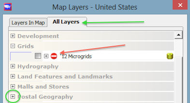
study area too large!
Notice above, the plus sign next to "Postal Geography" (green circle above). This indicates that "Postal Geography" is a category, and may be expanded to show the various postal layers underneath.
This little "plus" sign is an interface idiom meaning that the list is expandable by clicking, either directly on the plus sign itself, or on the list item to the right of it, to get more info.
Shown below is a list of postal geography features which may appear when you expand this list. Note again the Zip9 Segment Centroids with the "no-no" symbol next to it. There are even more Z9's than MicroGrids!
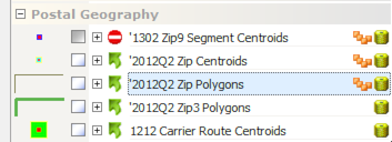
Finding the ZIP layer you want
The layer you are probably looking for is the ZIP code areas, known in mapping as the Zip Polygons. It is shown highlighted (above). The ZIP centroid layer consists of a "dot" shown at the population center of each ZIP code. In other words, if a ZIP is at the edge of the city, and spills over into 25 miles of countryside, the ZIP centroid will still be located closer to the city than stuck out in the middle of nowhere.
You can satisfy yourself that the centroid is at the population center by turning on both ZIP polygons and ZIP centroids -- just click in the checkbox next to each layer. The fact that the centroids do not appear reveals a peculiarity in their default theme appearance:

the peculiar case of ZIP centroids
Notice that ZIP centroids are configured to display ONLY the labels by default. You can see this when you expand the second "plus" and see the parts that make up the ZIP centroids: objects (1st line) and Object labels (2nd line). You can only get the symbol representing centroids to appear if BOTH checkboxes are filled in on that line.
There are three other things on the line. To the right, are a figure consisting of four tiny rectangles, and then a yellow cylinder. They cylinder indicates that there is demographic data on that layer. The tiny rectangles indicate that there is a grouping on the layer. One or more groupings, actually. These symbols are just symbols; in other words, they are not buttons. At the left side, however, is the symbol which will appear in the map when it is plotted. In the case of the Zip centroids, a large blue square with a tiny red dot in the middle. This is an active button, and pressing it will bring up a box which gives you the option to change it.
Similarly, the AaBbCc indicator at the left of the Object labels line is also a button, and pressing it gives you various options to modify the font, placement, and type of information which appears next to the object as a label, including the value of any data item carried by the object.
Now that we can delete and hide layers, and find ZIPs and MicroGrids, let's take a comprehensive way at how you add features to a map, including new features you create or import.
Add features to a map
In addition to what you have seen so far, where you add existing features via the 'All layers tab' of the Map Layers selection, there are five (5) other ways of adding a layer to your map.
- 1 Create Layer or click layer into the map (Objects Menu)
- 2 Import layer (Map Menu)
- layers organized by project folder
- 3 Dialogues adding layers: new areas or 'new locations'
- Find address.. (Map Menu)
- Find Coordinate.. (Map Menu)
- Copy objects (Objects Menu)
- 4 'Go to' layers (Map Menu)
- 5 Site Express layers (Reports Menu)
First, you can click the layer into the map. There are two identical paths to this function: 1) Choose 'Create Layer...' from the Objects menu, and specify Locations, Lines, Polygons or Areas or 2) from the Edit mode button, choose 'Edit locations,' 'Edit lines,' 'Edit Polygons,' or 'Edit Areas'.
Whichever way you choose, you then proceed to name your layer, specify the name of your save file, and click on the map to place your locations or concentric rings, or draw your lines or polygons.
Second, from the Map Menu you can choose "Import Layer.." and bring in your location file as a layer. In order to do this you need to have a latitude and longitude for each record in the file. This topic is covered in 'Working with Excel,' although comma-delimited and tab-delimited text files, plus dBase files, can be imported in addition to Excel files. Everything in mapping works via latitude and longitude, so your input file must have latitude and longitude for each record.
When you import a layer in this way, its source folder will be added to your Scan/US configuration as a project folder. Project folders can be deactivated/reactivated via the 'Project folders' dialog, which you may find on the Tools menu.
Third, you can activate dialogues adding layers, when you choose new areas or 'new locations' from a list of layers.
When you find the latitude/longitude coordinates of a point using either 'Find Address' (by entering the street address) or 'Find Coordinate' (by entering the coordinate directly), you have the opportunity to either A) add the location to an existing layer or B) to create a new layer. The dropdown where you make your choice shows the existing layer (this is an excellent way to stay organized while doing layer management), or two generic choices in brackets as follows:
[New Locations]
[New Areas]
This choice is also shown in Copy Objects, which we'll get to in a minute.
When you choose 'New Locations', you will be prompted to name the layer, and say where the file will be saved. You will also have an opportunity to name the point location.
The same is true of 'New Areas,' except you will have the additional choice of whether the areas layer you are creating will be concentric rings (or if you wish, you can choose just 1 ring) denominated in miles, or drive-time areas specified by minutes of driving time.
The new layer you create will appear on subsequent visits to this drop-down, and you can then proceed by adding locations to it one by one, as you enter new addresses or lat/long coordinates. It's a perfect way to do a study that just has 10 or 12 locations that you have the addresses of: you can create a location layer with the first "Find Address," and add to it on subsequent "Find Address" entries.
Now, about "Copy Objects." This is a very good shortcut way of creating either rings or drivetimes for a whole set of locations that you already have in the map. Suppose you have 100 store locations, already plotted on the map. When you use 'Copy Objects..' from the objects menu, it combines copying and pasting into a single step, walking you through the sequence of first specifying objects on the source layer, and then by choosing, as above, either new locations or new areas. You can specify the size and number of concentric rings or drivetimes you create for each source location.
Fourth, the automatic creation of 'Go To' layers. When you choose 'Go To' from the map menu, the point you 'went' to is shown on the map. It isn't a 'one-off' point; it has full citizenship as a layer. The layer it is part of is shown in the 'Go To' category of the 'All Layers' tab of Map Layers. If you want the layer to persist (in most cases you won't), you can navigate over there & rename it, and it will be saved.
Fifth and last, the automatic creation of Site Express Layers. When you run the Site Express report creation facility from the Reports menu of Scan/US, each location you enter will result in the creation of an area object, either a drivetime or concentric rings. These locations are entered into a layer that is named for the current date, and which can be found in the Site Express Sites category of the All Layers tab of the Map Layers dialog.
Introduction to The "style" dialog boxes
Five menu entries on the tools menu let you adjust various aspect of map and label display. A sixth, 'key style', gives you control over putting a location "key" indicator next to individual locations, and will be dealt with in a subsequent lesson.
Each of these appearance controls can be started up by choosing it from the menu, OR by clicking the button to the left of the layer, as shown by the green lines in the illustration below.
Here are the controls which can be activated. We'll talk about them one by one.
- Area style
- Symbol style
- Line style
- Label style
- Subarea label style
The diagram below shows commands on the Tools menu which do the same thing as the buttons in the Map Layers dialog.
Notice green circle in the middle of the Subarea label style indicator. This circles one of the "Subarea labels" for the concentric rings.
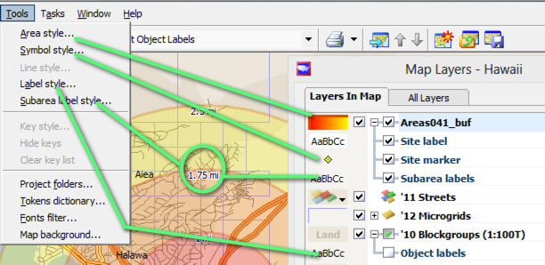
use the menu the button
Area style dialog
Most of this dialog contains functions which are fairly discoverable. You can try out different buttons and see how they change the appearance of the map.
Since this is our first style dialog, it's a good time to introduce a convenience interface control: the pushpin to the left of the 'Apply' button, shown below circled in green (green circle).
This convenient toggle pin "pins" the dialog open, so that when you press "Apply", the changes will take effect immediately in the map, but the dialog will not go away.
This makes it easier to try out different combinations, without re-activating this dialog box from the beginning. When you know exactly what you want, you can click the pin & it will lie back down on its side and not "pin the dialog open". In the clip below, it is show "pinned open."
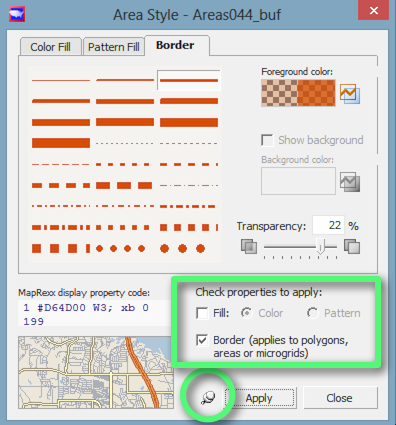
Area style dialog
The "Check Properties to apply" box (green rectangle above) lets you hide the interior fill (as shown above by the unchecked fill checkbox), and if desired, also hide the border. The tabs at the top let you choose border style, Pattern Fill, and Color Fill, while the checkboxes shown in the green rectangle above control whether they are applied or not.
Another characteristic is the level of transparency, controlled by a slider just above the green rectangle. The way to think about transparency is this: If you set transparency to 100 percent, you will not see the object at all.
If you set transparency to 1 percent, the objects on the layer will be almost entirely opaque. If you set it to 0 percent transparent, layer objects will be opaque, and the objects will be drawn underneath any transparent layers.
Symbol style dialog
The symbol style dialog lets you select a different depiction of objects on a location layer. The buttons along the left let you choose circles, squares, shapes, and icons & logos. Pin & tacks and font symbols are not implemented.
Icons and logos are very fun and easy to add. You can make a .png .jpg or .gif file, and place it in the symbols folder located at "users/your-user-name/my documents/ScanUS/symbols". When you do this, Scan/US will resize it so that it will fit in the map, and offer you a choice of symbols. Several illustrative symbols are included with the distribution.
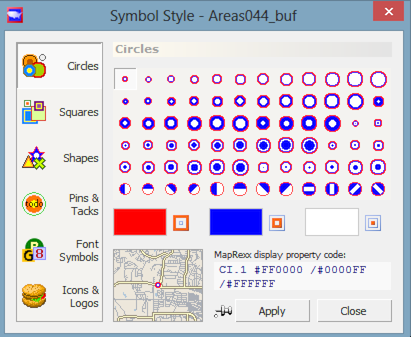
Symbol style dialog, showing circles
The color panels underneath the various button choices let you choose the outer color, the middle color, and the interior color of the symbol.
As with the other style dialogs, a small inset map (shown above directly beneath the red color-panel choice) is provided to show an example of how your choice would appear on a map.
Line style
The line style dialog is almost identical to the Borders panel of the Area style dialog shown above. If you draw lines into your map, this dialog may be useful.
Label style
The Label style dialog has two tabs: format, and content.
The format tab controls label color, font face and size, whether a frame is drawn around the label, and whether it is s p r e a d o u t or ALLCAPS. There is a checkbox to specify that a leader line be drawn from the label to its labeled point when the label is moved.
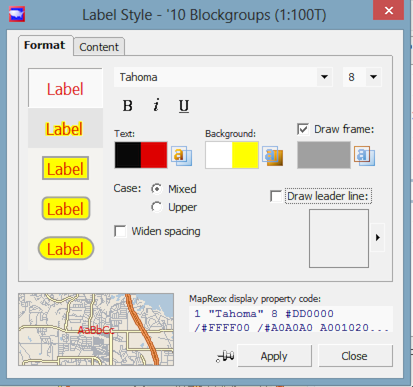
*Label style: 'format' tab *
The 'text' color well (shown in red above) controls the text color, while the 'background' color well (yellow, above) controls the background part of the text label. You can also specify the color of the frame around the map, which may improve label visibility considerably on a map with lots of detailed information. In other words, you will definitely need all of these buttons at some point!
The buttons along the left side (above) let you choose one of five types of label presentation.
The other tab of the Label style dialog, the 'Content' tab, lets you choose between showing the object identifier in one of several formats, OR showing demographic data for each object, choosing from a list that pops out to the right when you choose the data option (shown below:)
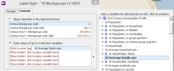
Label style: 'content' tab
To activate the data item(s) you want, first click on the Place holder message (shown above as "[Place holder:click to place variable here]"), and then choose the variable from the list at the right. After you have done this, you will see '[Click to Enter Tag]' appear, as shown above. This is where you click to enter any text you want to appear with the label, to the left of its number. Thus, if you want it to say "Avg fam size", click and type that in. Your tag will appear next to each block group's family size number, on block groups all over the map. So, name it wisely, because, like all naming in Scan/US, you are publishing the label to the readers of your map.
Subarea label style
Finally, the subarea label style dialog operates identically to the label style, but is applied to the sub-areas. As with the label style dialog for areas, the content labels and the leader lines do not apply to the subarea label style.
Adjust line style and fill
- of the map features that are built in
- After you load the feature
- As you load the feature
What about land mass?
- Different kinds of lines around groups
lines around ungrouped objects
Zoom ranges
What is a zoom range?
A characteristic of changes you make in the map, is that they apply at the current ZOOM RANGE.
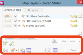
*the map layers dialog *
As you zoom in and out of the map, the lower right-hand corner of the Map Layers dialog will change to show the range (green rectangle below:)

*bottom of map layers dialog showing zoom ranges (red arrow indicates create legend button *
You can set up your map to have a different look at different magnifications, or 'zoom ranges'. Here is how this works: When you make a change, it is applied to the current zoom range, and to all zoom ranges below it. Zoom ranges that you reach by zooming OUT of the map are not affected.
This applies to object labels, as well. An example of this would be:
Suppose above 17 miles you want store locations to appear, but without map labels, but when you zoom in below 17 miles, you want store labels to appear.
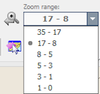
zoom ranges showing current zoom range
To accomplish this, first zoom out to the higher zoom range, and un-check the box next to map labels. The labels will disappear at that zoom level. Then zoom in to the lower zoom range and check the labels box, to make the labels appear at the lower range. Now, when you move the zoom slider up and down, the labels will appear at the desired zoom range.
Let us turn to some other label considerations: manual placement, and "what if my label doesn't appear?"
Manual label control
In case you missed the section on map features above, right next to each feature name in the Map Layers dialog is a little '+' sign, and when you expand it there is a checkbox to show labels for the layer. Also, an AaBbCc button that let you adjust the font, put data in the labels, and so forth.
Also, there is another type of label, called a key type of label, which will put a different letter - or number - next to your locations on the map. Since that isn't a basics 2 topic, we won't be talking about that here.
But .. what happens if the labels don't appear exactly where you want them to? Or .. what happens when you have clicked the checkbox to make labels active for the label, but the label you are interested in seeing STILL doesn't appear? Why is that happening, and what can you do to make sure it doesn't happen, whatever it is?
The reason they don't appear is due to Scan/US automatic label placement. If there isn't room for a label to appear without overlapping, Scan/US doesn't place it on the map. However, when you zoom in closer, and there is room for it to appear, it pops right up!
Automatic label placement is great, because it takes care of all sorts of things like highway signs, interstate shields, and so forth, without you having to worry about it.
But sometimes you will need to override automatic placement.
When you can select a label (be in object select mode, label submode by choosing the second-from-the-top mode button on the left) in the map, and move it around, it automatically is removed from the automatic label placement, and is put onto MANUAL mode. A label in Manual mode will always appear.
So, to make sure a label appears, select it and move it around to set it to manual.
Suppose you want ALL the labels on a map to appear, for example, all the counties in part of a state.
Fortunately, you can specify in the Object Manager to make all labels manual. To do this, open the Object Manager from the Objects menu, highlight all the objects for which you want manual labels, and choose the "make the labels manual" button at the bottom of object manager (indicated below by the green arrow) to turn them manual.
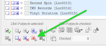
object manager manual labels button
When you click the 'red-small-a' button (set labels manual), you will notice that the auto-label indicator 'a' next to each object in the object manager will turn red, to indicate that the label is now manual.
And that is how you can guarantee that all labels in the map will be presented, for you to manually move them around. On a map with many objects, the labels will get quite crowded.
Legends
Two kinds of legend may appear in the map: the standard features legend, and a legend showing the results of classify-by-value, or data groupings. The first is called the 'features legend', while the other is called the 'group legend'
Group legend
When you make a grouping, either manually or by selecting 'Classify by value..' from the data menu, the group legend appears automatically in the lower left of the map.

Customizing the group legend using group manager
If you bring up the group manager for that grouping, you can customize the appearance of the location in the map, and in the group legend as well. Also, you can rename the grouping in the group manager, and this saved name will save with your study area. In the example above, you would right-click on 'record stores' to rename the grouping, and you would click on the button to the left of the "In view" column to get the Symbol style dialog for the group depiction. We have already talked about how to specify different symbol styles.
This is the best way to customize the group legend, since changes are saved into the grouping.
Further, you can right-click the group legend and choose "edit legend" from the context menu, to get the "Edit Grouping Legend" dialog, which will let you edit the legend title, subtitle, and how counts and percentages are displayed to the right of the group name.
Normally this would not be a "basics" topic. It's included because this is the only way to get user-imported objects into a legend: to group them, and edit the group legend so that it shows what you want.
As it happens, when you make a thematic map by choosing 'Classify by value' from the data menu, colored groups are formed, and if you wish to change the grouping color for the data ranges, you can also do this by selecting the group manager from the data menu and customizing the group colors from there.
Features legend
You can turn the 'features legend' on with the button at the bottom of the map layers dialog (indicated by red arrow below:)

Map layers dialog showing 'create map legend' button
When you do this, a simple map legend will be created. Here is an example of a simple legend:
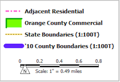
example of simple map legend
Notice that the thick blue line showing 'County Boundaries' looks a little bit TOO thick. If you go back and change the width in the Area Style selector for that feature, the legend will pick up your change.
You can also edit this further: right-click directly on the legend, and choose 'Edit Legend' to add a title, subtitle, and footer. Notice there is a scale in the legend.
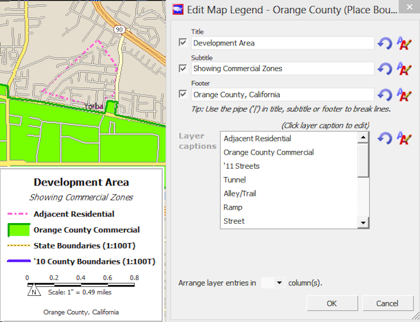
edited map legend
The line showing county boundaries is also thinner, just like we wanted.
If you notice there are layers such as "swamps", which appear in your legend, and you do not want them, simply UN-check the 'show reference cartography' in the Map layers dialog, and they will disappear from the legend.
Section 2 Exercise
- Make the labels appear for the States Layer. Change the display to the state name and make the font larger for each one. Zoom in to the East Coast and change some of the labels to manual, and move them off the coast so more than one label can be seen.